subscribe to newsletter
The hiking bug: up and down
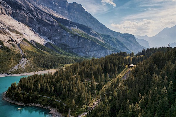
Do you love circular walks? Then this tip is definitely worth taking a look at! What makes it unique is that you are almost constantly walking along a wide ridge.
If the term ‘ridge’ makes you think of exposed passages or steep precipices, you really don’t need to worry. The ridge is wide along almost its entire length, and the landscape is breathtaking. Beautiful woodlands alternate with alpine meadows and you even cross a marsh; in fact, this stretch of path is the highlight of the hike. The hill climb is classified as T2 and so is not over-demanding. You should simply bring a little stamina with you, as the hike is just under 19 km.
Do you know what ‘Runs’ means in Swiss German?
Runs is a gully on a mountain slope, with a wild stream. And ‘Grosser’ does not refer to the size (Grösse in German), but is derived from the nearby village of Gross.
The circular trail around Grosser Runs
The starting point for this circular hike is the village of Grossbach (900 m.a.s.l.). You follow the asphalt road as far as Obergross (984 m.a.s.l.) then, in Bollerenwald, you turn right at waypoint 1113 and leave the asphalt road shortly afterwards. From here you follow the hiking trail leading to Chli Amseln. When you reach Chli Amseln, one of the trails leads south to Amselspitz (1491 m.a.s.l.). This short climb is the steepest stretch on this hike. When it’s behind you, you are rewarded with a fantastic view – although you also become aware of just how long this hike is! Next comes the first short descent, to Amslengschwänd and then on to Stockhütte. From there you continue towards Chopf (1559 m.a.s.l.) and walk round it to the east. After another short descent, you can climb up Buziflue. From the top, you turn west and make your way to Gschwändstock (1616 m.a.s.l.), which is the highest point on the circular trail. You will need to concentrate here, as the ridge becomes quite narrow for a short while. As soon as the path widens again, it turns to the north-east and takes you to Rägenegg. This section of the path crosses marshland; however, boards have been laid so your feet will stay dry! Now it's time for the penultimate ascent, up Spital (1574 metres above sea level). The hiking trail then takes you via Böliegg over Humel (1432 m.a.s.l.), when you finally have the last ascent behind you. Further to the north lies the Alp Unter Humel, which you pass. From here, the path goes quite sharply downhill, which means it doesn’t take too long to reach Grossbach again.
If you have hiked around the Grosser Runs, you can cool off right there in Grossbach, as the Grosser Runs flows through it. Or you can find a beautiful spot on the Sihlsee, which is popular with hikers as well as being a sought-after destination for kite surfers.
“Hiking means forgetting all haste and seeing what is left.”
− Rommert Boonstra –
Additional information
Duration and difficulty
Without breaks, this circular trail will take you 6.5 hours. It covers a total of 19 km with 1100 m of ascent (starting at Obergross). The hike is classified as a T2 – mountain hike, which means that there are no great difficulties. Sure-footedness and orientation abilities are nevertheless required.
Waypoints
- Grossbach (900 m.a.s.l.)
- Obergross (984 m.a.s.l.)
- Chli Amslen (1399 m.a.s.l.)
- Amselspitz (1491 m.a.s.l.)
- Chopf (1559 m.a.s.l.)
- Butziflue (1601 m.a.s.l.)
- Gschwändstock (1616 m.a.s.l.)
- Rägenegg (1531 m.a.s.l.)
- Spital (1574 m.a.s.l.)
- Bögliegg (1551 m.a.s.l.)
- Hummel (1423 m.a.s.l.)
- Unter Hummel (1269 m.a.s.l.)
- Grossbach (900 m.a.s.l.)
References
Amselspitz, Butziflue & Spital [hikr.org]
Rund um den Grosser Runs: Tolle Aus- und Tiefblicke (hrm-auer.ch)